Le plus grand référentiel d'articles scientifiques au monde. 70,000,000+ d'articles gratuitement.
Campagne de collecte 15 septembre 2024 – 1 octobre 2024
Z-Library est une des plus grandes bibliothèques en ligne dans le monde, avec le stockage de plus de 17,000,000 livres et plus de 84,837,000 articles. Nous encourageons l'accès libre de chacun à la littérature. Aujourd'hui (15 septembre 2024) nous faisons un appel de fonds à tous ceux qui veulent contribuer encore plus au soutien et au développement de notre projet.
Les téléchargements SANS LIMITE sont aussi (au cours de 31 jours après la date de don) disponibles pour TOUS les utilisateurs qui soient en mesure de soutenir le projet pendant la période de collecte de fonds jusqu'au 1 octobre 2024.
Les Z-Alerts vous permettront de recevoir une notification lorsque de nouveaux livres correspondant à votre recherche sont disponibles. La recherche peut comporter le titre d'un livre, le nom de l'auteur, ISBN et d'autres informations En savoir plus sur Z-Alerts.
1
Suivez ce lien ou recherchez le bot "@BotFather" sur Telegram
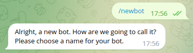
2
Envoyer la commande /newbot
3
Entrez un nom pour votre bot
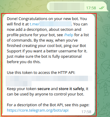
4
Spécifiez le nom d'utilisateur pour le bot
5
Copier le dernier message de BotFather et le coller ici